Toronto Weather
Weather in Toronto, Ontario: current conditions, forecast, warnings, monthly averages and seasonal guide
12°C
Overcast
Updated 28 Apr, 12:19 pm
High / Low
14°C / 10°C
Feels Like
10°C
Humidity
90%
Wind
S 15 km/h
Wind Gusts
36 km/h
Dew Point
10°C
Pressure
991 hPa
Rain Today
0 mm
UV Index
2.5 Low
Hourly forecast
Now
14°C
12%
19km/h
17:00
13°C
25% 0.2mm
15km/h
18:00
13°C
16% 0.4mm
13km/h
19:00
14°C
2%
5km/h
20:00
14°C
9km/h
21:00
13°C
11km/h
22:00
12°C
1%
11km/h
23:00
11°C
1%
10km/h
Wed 29 Apr
00:00
11°C
10km/h
01:00
11°C
9km/h
02:00
10°C
9km/h
03:00
10°C
3km/h
04:00
10°C
4km/h
05:00
8°C
5km/h
06:00
7°C
5km/h
07:00
8°C
1%
4km/h
08:00
8°C
1%
9km/h
09:00
8°C
1%
13km/h
10:00
8°C
1%
16km/h
11:00
8°C
3%
13km/h
12:00
8°C
8%
10km/h
13:00
9°C
22%
10km/h
14:00
9°C
29% 0.7mm
12km/h
15:00
9°C
36%
10km/h
16:00
8°C
31% 1.8mm
14km/h
17:00
7°C
32%
14km/h
18:00
7°C
26%
15km/h
19:00
7°C
25%
15km/h
20:00
6°C
17%
12km/h
21:00
6°C
3%
13km/h
22:00
5°C
28%
14km/h
23:00
4°C
28%
14km/h
Thu 30 Apr
00:00
4°C
28%
16km/h
01:00
4°C
28%
14km/h
02:00
4°C
28%
15km/h
03:00
4°C
7%
15km/h
04:00
4°C
7%
14km/h
05:00
3°C
7%
13km/h
06:00
4°C
7%
15km/h
07:00
4°C
7%
16km/h
08:00
4°C
7%
17km/h
09:00
5°C
2%
19km/h
10:00
7°C
2%
18km/h
11:00
8°C
2%
16km/h
12:00
9°C
2%
15km/h
13:00
10°C
2%
15km/h
14:00
10°C
2%
16km/h
15:00
9°C
7%
14km/h
7-day forecast for Toronto
| Day | Conditions | Rain | Temp | Summary | |
|---|---|---|---|---|---|
| Today28 Apr | Light drizzle | 76%1mm | 14°C10°C | Light drizzle with a high of 14°C and low of 10°C. 76% chance of rain, up to 1mm. UV index 2.5 (low). | |
| Wed29 Apr | Slight rain | 36%2.5mm | 11°C4°C | Slight rain with a high of 11°C and low of 4°C. 36% chance of rain, up to 2.5mm. UV index 2.5 (low). | |
| Thu30 Apr | Light drizzle | 28%0.2mm | 10°C3°C | Light drizzle with a high of 10°C and low of 3°C. 28% chance of rain, up to 0.2mm. UV index 6.3 (high). | |
| Fri1 May | Light drizzle | 7%1.2mm | 10°C2°C | Light drizzle with a high of 10°C and low of 2°C. 7% chance of rain, up to 1.2mm. UV index 4.8 (moderate). | |
| Sat2 May | Overcast | 5% | 9°C1°C | Overcast with a high of 9°C and low of 1°C. 5% chance of rain. UV index 6.1 (high). | |
| Sun3 May | Overcast | 10% | 6°C2°C | Overcast with a high of 6°C and low of 2°C. 10% chance of rain. UV index 3.5 (moderate). | |
| Mon4 May | Overcast | 25% | 8°C3°C | Overcast with a high of 8°C and low of 3°C. 25% chance of rain. UV index 2.4 (low). |
Extended outlook — days 8 to 14
Extended forecasts beyond 7 days are less reliable and should be used as a general guide only.
| Day | Conditions | Rain | Temp | Summary | |
|---|---|---|---|---|---|
| Tue5 May | Moderate drizzle | 22%3.3mm | 11°C3°C | Moderate drizzle with a high of 11°C and low of 3°C. 22% chance of rain, up to 3.3mm. UV index 1.3 (low). | |
| Wed6 May | Slight rain | 32%5.7mm | 14°C6°C | Slight rain with a high of 14°C and low of 6°C. 32% chance of rain, up to 5.7mm. UV index 4.3 (moderate). | |
| Thu7 May | Overcast | 23% | 10°C5°C | Overcast with a high of 10°C and low of 5°C. 23% chance of rain. UV index 1.8 (low). | |
| Fri8 May | Overcast | 19% | 9°C4°C | Overcast with a high of 9°C and low of 4°C. 19% chance of rain. UV index 3 (moderate). | |
| Sat9 May | Overcast | 27% | 10°C4°C | Overcast with a high of 10°C and low of 4°C. 27% chance of rain. UV index 3.4 (moderate). | |
| Sun10 May | Light drizzle | 19%0.6mm | 13°C6°C | Light drizzle with a high of 13°C and low of 6°C. 19% chance of rain, up to 0.6mm. UV index 5.4 (moderate). | |
| Mon11 May | Overcast | 16% | 17°C3°C | Overcast with a high of 17°C and low of 3°C. 16% chance of rain. UV index 6.4 (high). |
Sun & Moon — Toronto
Sunrise06:13
Sunset20:16
Daylight14h 3m
PhaseWaning Gibbous
Illumination83%
UV Index — Toronto
2.5
Low
03681114
No protection needed. You can safely enjoy being outside.
Air Quality — Toronto
38
Fair
020406080100+
PM2.56.3 µg/m³
PM106.9 µg/m³
US AQI50
Air quality is acceptable. Unusually sensitive people should consider limiting prolonged outdoor exertion.
Air quality data from Open-Meteo
Climate overview
Toronto experiences a humid continental climate, classified as Dfa under the Köppen system. This classification is characterized by four distinct seasons with warm to hot, humid summers and cold, snowy winters. Its latitude, approximately 43 degrees North, places it within the mid-latitudes, where it is subject to the clash of polar and tropical air masses, creating dynamic and often rapidly changing weather patterns throughout the year. The city's position on the north shore of Lake Ontario significantly moderates its climate, especially during transitional seasons.
The extensive Great Lakes system, particularly Lake Ontario, plays a crucial role in shaping Toronto's weather. In winter, the lake's relatively warmer waters release heat and moisture into the atmosphere, leading to increased cloudiness and lake-effect snow in areas downwind of the lake. Conversely, in spring, the cooler lake waters slow the warming of the land, often delaying the onset of warmer temperatures compared to inland areas. This maritime influence, though from a freshwater body, creates a unique microclimate distinct from more inland continental regions at similar latitudes.
Prevailing winds in Toronto largely originate from the west and southwest, particularly during summer, bringing warm, humid air from the interior of North America. These winds are often responsible for summer heatwaves and thunderstorm activity. In winter, northwesterly winds often bring cold, dry arctic air masses, leading to significant drops in temperature and contributing to the lake-effect snow phenomena. The interaction of these air masses throughout the year defines the characteristic variability of Toronto's weather, with abrupt shifts possible within short periods.
Compared to cities like Chicago, which is also on a Great Lake, Toronto generally experiences slightly milder winters due to Lake Ontario's moderating influence. However, it can still endure severe cold snaps when arctic air masses dominate. Its climate differs significantly from coastal cities at similar latitudes, such as Marseille, France (Csa - Mediterranean), which benefit from warmer ocean currents and rarely experience severe winter cold or snow. Toronto's inland position, despite the lake, still retains a strong continental signature with larger temperature extremes.
Toronto receives approximately 830mm (32.7 inches), distributed relatively evenly throughout the year, with a slight peak in summer months due to convective thunderstorms. of rainfall annually, with the wettest months from June, July, and September generally receive the most precipitation, often in the form of heavy summer thunderstorms.. Toronto typically enjoys around 2,066 hours of sunshine annually. This translates to an average of 8-10 hours per day in summer, providing ample daylight for outdoor activities, while winter sees a reduction to 3-4 hours per day, though bright, crisp days are common. The high summer sunshine, combined with its mid-latitude position, means UV levels can be very high, necessitating strong sun protection. Even in winter, reflective surfaces like snow can increase UV exposure, so year-round awareness is important for those spending extended time outdoors.
Toronto's microclimate is significantly influenced by Lake Ontario, leading to noticeable variations across the city. Coastal areas directly adjacent to the lake experience a moderating effect; winters are slightly milder with less extreme cold, and summers are often cooler with refreshing lake breezes compared to inland neighborhoods. This "lake effect" can also concentrate snowfall in certain areas downwind of the lake during ideal conditions.
The dense urban core of Toronto exhibits a pronounced urban heat island effect, particularly at night. Concrete and asphalt absorb and re-emit heat, raising temperatures by several degrees compared to surrounding suburban or rural areas. This can lead to warmer nights, especially during summer heatwaves. Topographic features, though subtle, also play a role, with slightly higher elevations further north experiencing marginally cooler temperatures and potentially different precipitation patterns. Strong lake breezes, known as "thermals," are a daily occurrence in summer, providing relief to lakeside communities but diminishing further inland.
Monthly averages for Toronto
Climate data sourced from Environment and Climate Change Canada climate data for Toronto. Summer temperatures range from 20°C to 30°C, often exceeding 30°C with high humidity during heatwaves, making for very warm conditions., while winter sits between -1°C to -10°C, with temperatures often dropping significantly lower during arctic air incursions, accompanied by substantial snowfall..
| Month | Avg High | Avg Low | Rain (mm) | Rain Days |
|---|---|---|---|---|
| January | -1.5°C | -7.9°C | 62.4 | 14.8 |
| February | -0.6°C | -7.3°C | 59.9 | 11.2 |
| March | 4.1°C | -2.7°C | 60.1 | 11.4 |
| April | 11.3°C | 3.6°C | 75.3 | 11 |
| May | 18.2°C | 9.7°C | 70.5 | 11 |
| June | 23.7°C | 15.1°C | 71.9 | 10.5 |
| July | 26.6°C | 18°C | 69.8 | 9.9 |
| August | 25.4°C | 17.4°C | 79.3 | 9.9 |
| September | 20.9°C | 13°C | 84.7 | 10.9 |
| October | 13.9°C | 7°C | 70.3 | 11.4 |
| November | 7.4°C | 1.9°C | 84.4 | 11.4 |
| December | 1.9°C | -3.7°C | 71.3 | 13.5 |
Water temperature
Lake Ontario water temperatures vary dramatically by season. During summer, from July to August, the lake warms up to a comfortable 18–24°C (64–75°F), making it suitable for swimming, especially at designated beaches like Woodbine Beach and Ward's Island Beach. Wetsuits are generally not required for casual swimming during peak summer months, though they can extend comfort for longer periods or cooler days.
However, water temperatures drop significantly in autumn and winter, reaching 0–4°C (32–39°F) and requiring specialized cold-water gear for any water activities. These frigid temperatures support specific cold-water marine life. Estuary and harbour areas may warm slightly faster in spring and cool slower in autumn due to shallower depths, but overall, Lake Ontario remains very cold outside of peak summer.
Summer water temperatures around Toronto range from 18–24°C (64–75°F), cooling to 0–4°C (32–39°F) in winter.
Things to do this summer in Toronto
Summer in Toronto demands light, breathable clothing such as cottons and linens. High UV levels mean broad-brimmed hats, sunglasses, and reef-safe sunscreen with a high SPF are essential, even on cloudy days. Stay hydrated by carrying a water bottle. Driving conditions are generally good, but be mindful of increased traffic during festivals and potential heavy downpours during thunderstorms, which can reduce visibility. Pack a light jacket for cooler evenings or air-conditioned indoor spaces.
- Enjoy a ferry ride and relax at Ward's Island Beach
- Attend the Caribbean Carnival parade
- Explore the Toronto Islands by bike or on foot
- Catch a Blue Jays game at Rogers Centre
- Experience outdoor concerts at Budweiser Stage
- Stroll through Kensington Market and enjoy patio dining
- Visit the Toronto Zoo and African Savanna habitat
- Take a boat tour on Lake Ontario for city skyline views
Best time to visit Toronto
The best time to visit Toronto is during the late spring (May to June) and early autumn (September to October). These shoulder seasons offer pleasantly warm temperatures, lower humidity, and fewer crowds than the peak summer months. It is ideal for exploring parks, attending outdoor events, and enjoying patio dining.
Summer, from July to August, brings vibrant city life, numerous festivals, and hot weather perfect for waterfront activities and island escapes. While popular, be prepared for high temperatures, humidity, and larger crowds. Early fall also presents stunning fall foliage, particularly in areas just outside the city, making it perfect for scenic drives and hikes.
Visitors should consider avoiding the depths of winter (January to March) if not accustomed to cold temperatures and heavy snowfall, as conditions can be challenging for sightseeing. However, winter offers unique experiences like ice skating, indoor cultural events, and cozy dining. Late spring and early autumn strike the best balance for comfort and a wide range of activities.
Weather radar — Toronto
View live rain radar for Toronto
Live radar imagery from the official weather service →
Weather warnings & safety
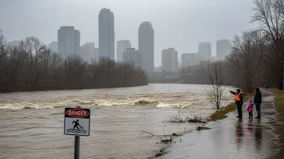
Toronto is susceptible to several severe weather phenomena, primarily occurring in summer and winter. Summer brings the risk of severe thunderstorms, which can produce heavy rainfall, leading to localized flash flooding, damaging winds, and hail. Tornadoes, though less common, are a risk, particularly in the Greater Toronto Area.
Heatwaves are a recurring summer concern, with prolonged periods of high temperatures and humidity posing health risks. Winters are characterized by extreme cold snaps, blizzard conditions, and significant snowfall, which can disrupt transportation and pose frostbite risks. While not directly in a hurricane path, remnants of tropical storms can bring heavy rain and strong winds. Droughts can occur, stressing water resources and increasing fire risk in natural areas, though large-scale bushfires are rare within the city itself.
Official warning sources: Environment Canada Public Weather Alerts · City of Toronto Extreme Weather Alerts
Latest weather news — Toronto

Weather near Toronto
Frequently asked questions about Toronto weather
What is the weather in Toronto right now?
Right now in Toronto it is 12°C and overcast. Today's high is 14°C with a low of 10°C. Humidity is at 90%. Wind is S at 15 km/h.
What is the 14-day forecast for Toronto?
Today (28 Apr): Light drizzle with a high of 14°C and low of 10°C. 76% chance of rain, up to 1mm. UV index 2.5 (low). Wed (29 Apr): Slight rain with a high of 11°C and low of 4°C. 36% chance of rain, up to 2.5mm. UV index 2.5 (low). Thu (30 Apr): Light drizzle with a high of 10°C and low of 3°C. 28% chance of rain, up to 0.2mm. UV index 6.3 (high). Fri (1 May): Light drizzle with a high of 10°C and low of 2°C. 7% chance of rain, up to 1.2mm. UV index 4.8 (moderate). Sat (2 May): Overcast with a high of 9°C and low of 1°C. 5% chance of rain. UV index 6.1 (high). Sun (3 May): Overcast with a high of 6°C and low of 2°C. 10% chance of rain. UV index 3.5 (moderate). Mon (4 May): Overcast with a high of 8°C and low of 3°C. 25% chance of rain. UV index 2.4 (low). Tue (5 May): Moderate drizzle with a high of 11°C and low of 3°C. 22% chance of rain, up to 3.3mm. UV index 1.3 (low). Wed (6 May): Slight rain with a high of 14°C and low of 6°C. 32% chance of rain, up to 5.7mm. UV index 4.3 (moderate). Thu (7 May): Overcast with a high of 10°C and low of 5°C. 23% chance of rain. UV index 1.8 (low). Fri (8 May): Overcast with a high of 9°C and low of 4°C. 19% chance of rain. UV index 3 (moderate). Sat (9 May): Overcast with a high of 10°C and low of 4°C. 27% chance of rain. UV index 3.4 (moderate). Sun (10 May): Light drizzle with a high of 13°C and low of 6°C. 19% chance of rain, up to 0.6mm. UV index 5.4 (moderate). Mon (11 May): Overcast with a high of 17°C and low of 3°C. 16% chance of rain. UV index 6.4 (high).
What is the air quality in Toronto today?
The current air quality index in Toronto is 38 (European AQI), rated "Fair". Air quality is acceptable. Unusually sensitive people should consider limiting prolonged outdoor exertion. PM2.5 is 6.3 µg/m³. PM10 is 6.9 µg/m³.
What is the air quality in Toronto today?
Toronto's air quality can fluctuate due to local emissions, regional transport of pollutants, and weather patterns. You can find the most up-to-date Air Quality Index (AQI) and specific pollutant levels (like PM2.5 and PM10) on the dedicated /weather/air-quality page. This page provides real-time data and health advisories, enabling you to make informed decisions about outdoor activities. Factors like industrial activity, vehicle emissions, and even forest fires from distant regions can influence local air quality.
Why is Toronto air quality so bad today?
Poor air quality in Toronto is often linked to a combination of factors. Heat and sunlight can trigger the formation of ground-level ozone, especially in summer. Additionally, particulate matter (PM2.5 and PM10) from vehicle exhaust, industrial sources, and sometimes even smoke from distant wildfires (as has been observed in recent years) can be trapped by stagnant air masses. Check the /weather/air-quality page for specific causes and regional advisories relevant to the current conditions.
When will Toronto air quality improve?
Improvements in air quality are highly dependent on changing weather patterns, particularly wind direction and speed. Strong winds can disperse pollutants, and frontal systems often bring cleaner air to the region. Rainfall can also help by washing particulate matter out of the atmosphere. Consult the /weather/air-quality page and the hourly wind forecast on /weather/wind for insights into when conditions might improve based on predicted meteorological shifts.
What time is sunset in Toronto?
The exact time of sunset in Toronto varies significantly throughout the year due to the Earth's tilt and orbit. During the longest days of summer, sunset can be as late as 9:00 PM, while in the shortest days of winter, it can occur as early as 4:30 PM. For precise daily sunset times, as well as sunrise and moon phase information, visit the /weather/sunrise-sunset page. This comprehensive resource also provides a 14-day astronomical table.
Where to watch sunset in Toronto?
Toronto offers several fantastic spots to watch the sunset. Popular locations include the Toronto Islands, which provide stunning panoramic views of the city skyline silhouetted against the setting sun. High Park, particularly from its higher vantage points, also offers beautiful vistas. Along the waterfront, places like Sugar Beach or the Harbourfront Centre can provide picturesque sunsets over Lake Ontario, especially when the colours reflect off the water.
How windy does it get in Toronto?
Toronto can experience significant winds, especially during frontal passages or strong low-pressure systems. Average wind speeds are typically moderate, but gusts can frequently exceed 50 km/h, particularly around Lake Ontario or during severe thunderstorms. You can find real-time wind speeds, hourly forecasts, and a 14-day wind summary, including gust predictions, on the /weather/wind page. These details are crucial for planning outdoor activities, especially boating or cycling.
What is the UV index in Toronto like?
Toronto's UV index varies greatly by season and time of day. In summer, the UV index can frequently reach high to very high levels (7-10+), especially between 11 AM and 4 PM, necessitating strong sun protection. Even on cloudy days, UV radiation can penetrate, and snow cover in winter can reflect UV, increasing exposure. The dedicated /weather/uv page provides the current UV index, an hourly breakdown, and a 7-day forecast, along with essential sun protection guidance.
How much rain does Toronto get?
Toronto receives an average of approximately 830mm of precipitation annually, distributed fairly evenly across the months, though summer thunderstorms can lead to heavier individual rainfall events. The city experiences around 130 days of measurable precipitation each year. For a detailed 14-day rainfall forecast, including cumulative precipitation and historical data, please refer to the /weather/rainfall page. This resource helps you prepare for wet weather conditions.
What are the moon phases for Toronto?
The moon phases in Toronto follow the regular lunar cycle, with distinct new moon, first quarter, full moon, and last quarter phases occurring approximately every 29.5 days. These phases influence the moon's visibility and illumination in the night sky. For a comprehensive 14-day table of moon phases, rise and set times, and illumination percentages for Toronto, visit the /weather/sunrise-sunset page. This information is useful for stargazers and photographers.
What should I wear for Toronto weather?
Given Toronto's four distinct seasons, packing requires versatility. In summer, light, breathable clothing is essential, along with sun protection. Autumn and spring demand layers, including a waterproof jacket and comfortable walking shoes, due to variable temperatures and frequent rain. Winter requires heavy, insulated outerwear, including a warm coat, hat, gloves, and waterproof boots to combat cold temperatures and snow.
How does Lake Ontario affect Toronto's weather?
Lake Ontario significantly moderates Toronto's climate. In winter, the lake's relatively warmer waters can lead to increased cloudiness and lake-effect snow in downwind areas, while also keeping extreme cold at bay initially. In spring and early summer, the cooler lake can delay the arrival of warmer temperatures for lakeside regions and create refreshing lake breezes. This moderating effect reduces temperature extremes compared to more inland locations.
Is Toronto prone to severe thunderstorms?
Yes, Toronto is prone to severe thunderstorms, particularly during the late spring and summer months. These storms can bring intense lightning, heavy rainfall leading to localized flash flooding, damaging winds, and occasionally large hail. While less common, the broader GTA region has experienced tornadoes. Monitoring local weather alerts and the hourly forecast on the /weather/hourly page is advisable during warm, humid periods for safety.
What are driving conditions like in winter in Toronto?
Winter driving conditions in Toronto can be challenging due to snow, ice, and freezing rain. Major roadways are generally well-maintained, but residential streets can become difficult to navigate. Drivers should exercise extreme caution, reduce speeds, and allow extra braking distance. Winter tires are highly recommended. Always check the latest road conditions and advisories from local authorities before travelling, especially during or after a snowfall, to account for potential delays and hazards.
How reliable is the hourly weather forecast for Toronto?
The hourly weather forecast for Toronto provides a detailed breakdown of temperature, precipitation, wind, and humidity for the next 48 hours, making it highly useful for short-term planning. While generally very accurate for the immediate future, forecast reliability naturally decreases with time. It's an excellent tool for deciding what to wear for your commute or planning outdoor activities for the day. For the most up-to-date hourly forecast, always refer to the /weather/hourly page.